


Aiguille du Goléon par le Serret Blanc

Thomasdanielle
User


--
Difficulty : Difficult

FREE GPS app for hiking
 SityTrail
IGN / Geographical institutes
SityTrail Plus
The world is yours!
About
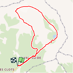
Trail On foot of 18.5 km to be discovered at Provence-Alpes-Côte d'Azur, Hautes-Alpes, La Grave. This trail is proposed by Thomasdanielle.
Description
D/A : km 0 - alt. 1895m - Parking d'Entraigues
1 : km 1.92 - alt. 2367m - Station de captage d'eau
2 : km 2.36 - alt. 2502m - Replat sous le Cruq des Aiguilles
3 : km 4.38 - alt. 2824m - Col sous le Serret Blanc
4 : km 5.12 - alt. 2984m - Promontoire bordant le couloir vers la crête
5 : km 5.63 - alt. 3206m - Col sous le Bec Grenier
6 : km 6.57 - alt. 3413m - Aiguille du Goléon
7 : km 11.39 - alt. 2484m - Passerelle
8 : km 13.64 - alt. 2438m - Barrage micro-centrale - Lac du Goléon
D/A : km 16.47 - alt. 1895m - Parking d'Entraigues
Ref. carte 3435ET, 3435ETR
Positioning
Comments